
The Planning Process
The task of doing a master plan for a subdivision is a very challenging task for any designer. The planning activity and design do not come easily. It goes along with much study, observation, research, and analysis.


Subdivision Planning
It is one of the comprehensive services rendered by an architect.
This project is a good subject to share, as we initially do the research, I decided to share the journey hoping that you can learn from this experience.
The Design Process
How did it all start?
It is very important to share the history of how this project came into place.
It was amid a global pandemic when this project was conceived. When MM Cortez had initial contact with the client whose mother-in-law, the land owner, won her case from this disputed land. As a result of that, they have decided to do some developments but have no idea what to do and where to start.
Basically, it is located at barangay San Isidro. The land is lying along the barangay road and it is mainly a gateway towards the main hub of the barangay. The main hub is the heart of the community where there are schools, mixed with residential and agricultural land.
The Site Analysis
These are the site pieces of information that are essential in the decision-making. To make a more realistic design approach that will help build the community. From the Macro to the Micro level of information, we can get much information as we unfold each of the data gathered from our research. All of these are readily available upon site visitation taking some photographs of the actual condition of the neighborhood and assessing the marketability of the site in terms of its location and accessibility.
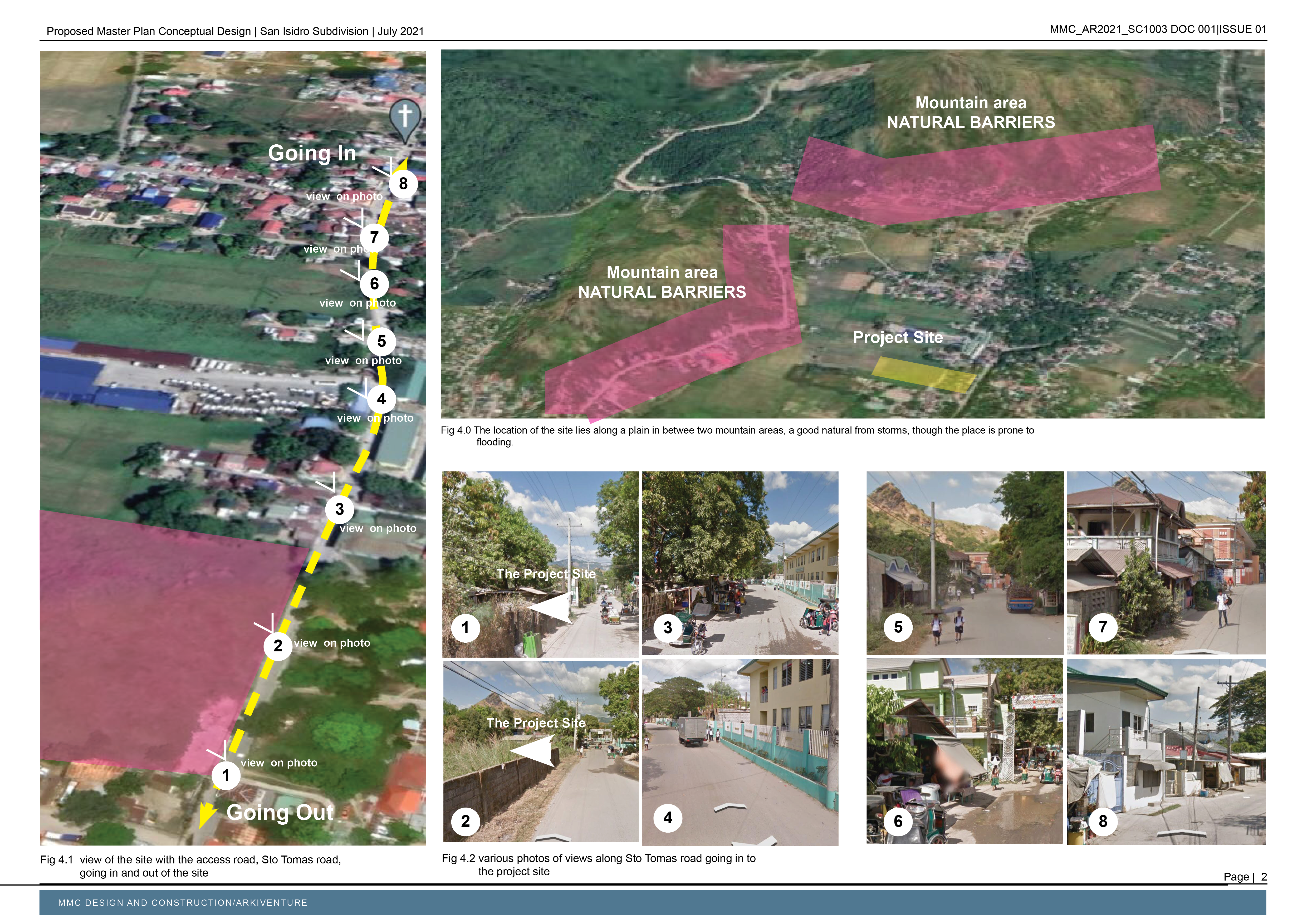
The Circulation and Accessibility to the Site
The flow of circulation and accessibility to the site is one of the major factors in determining the targeted market. As we go deeper into the feasibility of this project, we can see the actual condition of the site such as the width of roads, availability of the transportation system, and the nearest access to important entry and exit points.

After the site survey, a careful analysis of the site is done. The survey includes;
The area of the site
- Location of the site
- The Land use
- The Existing condition which includes the terrain, utility system, road, vegetation and natural resources, population, etc
- Livable neighborhoods and the growth hub
- Probable impact on existing development and adjacent developments
- The future developments
Design Standards
What governs the design standards of subdivision planning and design?
Subdivision planning and design standards are governed by local government guidelines. It follows government regulations in protecting life, health, and property. And achieving aesthetic goals for the community.
General Design
The major design guidelines and patterns take into consideration the surrounding land use and other natural constraints that impact the quality of the project.
Subdivision Planning
The basic framework of the layout is determined by the layout of the street to form a pattern and arrangement of lots.


This subdivision plan in its design process still goes a long way. We are just starting with the presentation of the initial design and some of the research and data gathered. The design can change as we continually discuss with the client.
Schematic Design Proposal
The initial study was made, and a schematic layout was done initially to show an impression based on the initial data gathered. This includes the number of lots allocated for the different land uses needed to make a sustainable community. Here's the Aerial View Perspective

To show the blueprint of what is the intent of the proposal, this graphical presentation is to guide the project proponent and the architect with their design goals. This will lead to a better understanding of how the design brief is met. This process will be a daunting task because we need to support the visual presentation with documents like the lot plan, budgetary estimate, and the overall arrangement of the subdivision plan to achieve maximum capacity. This will include.
- The Financial feasibility studies
- The overall impact of the site to the end-user
- The interrelationship of spaces and their accessibility
We will update you soon.
Meanwhile, as you enjoyed reading, I would like to ask some questions.
1. How will you describe the design of the master plan?
2. With the process shown, what else is missing?
You can share your thoughts in the comment section below, I would be glad to have a healthy discussion to dig deeper into the design of the subdivision plan.


