Friday, November 19, 2021

Architectural Renderings

 Architectural Rendering Contributions


This will give you an update to Our original website at 3dartrender where we have received several contributions and would like to accommodate them here in our blogpost. We have experienced some technical issues with our website and the Domain name registration expired so we cannot keep our files in our website. But there some of the few valuable images you might want to look back and We believe it still stand today. 


We would like to re post some of their Valuable Contributions here:


Thanks to our first contributor Architect Jason Sanga

The featured image is one of his 3d renderings using 3dStudio max and Vray at that time. 
The type of rendering presentation still match up with Lumion and other latest rendering engine today.


This is another finest example of high quality 3d rendering presentation since 2012. The intricate detaiks of the landscape, the subtleness of the shadows and shades controlled by lighting and ambient occlusion that penetrates through the completeness of the details of the structures and a good camera position to create this wonderful imagery. 


Thr Landscape architecture demands a good presentation of trees and shrubberies as well. 
Nowadays, a lot has improved but it is still the artist’s eye that can create a timeless 3d rendering presentation as this. 

Let’s keep up with our past heritage and relive the moment. 

We will post more from other contributors as well as we uncover some of our contributors work. 

Please do watch out for our upcoming blogs.

If you are a 3d enthusiasts, whether just doing it as a hobby or a full grown professional, you are most welcome to share your contributions. Connect with our facebook page @3dartrender. 

Monday, November 15, 2021

A Waterwheel project | What benefit can we get?

 A waterwheel project |  What benefit can we get?


In our design approach to develop a riverbank, one of the key features to make use of our natural resources and its potential benefit to the community is in the use of the waterwheel. A device that can be placed in the river to generate power supply.

This will help us explore the uses and benefits to the community and make this as a starting point as well to improve and develop in the next 10 years and beyond as the rise of digital age has broke out so fast. 

To explore the benefits and identify what needs to be done to improve it and how it will achieve an eco friendly environment with this device. It would be best to know what is a waterwheel and its benefits discussed below.  

What is a waterwheel?


It is a type of device that runs like a watermill that generates power. With the use of set of paddles and mounted around the wheel that takes advantage of the flowing water from the river. It runs like a mill race from the river to the waterwheel. 
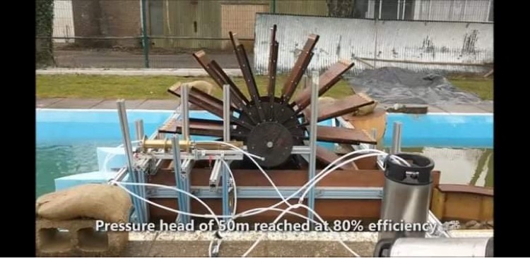
Apart from generating power supply, a 1.6 meter diameter generates power supply of 1000watts at 85% efficiency and a water purifier. Fig below shows a test result with that results achieved. The test output proved that 15% was drinkable while the remaining 85% rejected as a high pressure stream.


With these test results we can derive a potential benefit from the river, thus making our device more efficient  to make use of our very rich natural resource like the river at naglabusan, Castillejos, Zambales. 

What are the benefit it can give to the community?

What we see are the surface of generating power and purified water production. This is a good opportunity yo develop those adjacent lots. The public domain and the private properties as well. 
This will be turn into a sustainable gem. There are plenty of opportunities to develop the riverside starting from this part of the river at naglabusan. It will set as a role model in the governments effort to develop an eco friendly environment, improve the life of the people, make their untapped properties into a high value productive farm of organic plants. 

What design opportunities it gives to architects and engineers?

Our attempt to develop the riverbank would create income opportunities to the nearby residents and create an attractive farm tourism destination. 
Philippines is an agricultural land but unfortunately, we have lost farmers diverting into other ventures. This is what we would like to address. 
Making the land more productive, promote and upgrade our agricultural system by helping farmers become more productive and elevate their means of income. 
This e we will also open more door of opportunities to promote our agricultural products that will supply not only our own country but as an international supplier of highly organic produce. 

Designing for the future

The future is so bright that the initial design study would lead to an in depth research and development studies. As mentioned earlier, to become internationally competitive, we will make use every effort to combine digitalization in our project. 

The Design approach and our analysis

The design approach is to connect both ends, the public realm and the private property development. Starting out with the Barangay resolution, this has given us the green signal to proceed with our design studies. 

The location of waterwheel will be strategically place in such a way that it can serve both the riverside ares ( public domains) and the adjoining property which is our client. They have consulted as and showed us the area and explore what can be done. As huge as it is,one big question arises, 

are we able to afford developing tge land”? 

Considering that they are a family of farmers, it will be a huge and impossible task to develop the land. 

It covers an entire area of approximately 89 hectares with a hill in the middle. 

Apart from that, what do we need to do to help them realize this big dream?

in our design approach, we drafted a framework to identify the different avenues where we can start the development. 

The whole stretch of the river goes along 500 meter parallel to our project site which is a good opportunity to complement our farm tourism project. 


The photo shows the whole stretch of the river and the hill. The main road is connected by a bridge where the river cuts through, and get into our site which is a perfect transition point where tge waterwheel project can be done. Both ways, it will then serve the public and private properties. The exact location is under study while we consider the flow of water if it creates a strong current, however, we can device a reroute of tge river flow to create  a turbine that will provide more speed of water flowing and will create stronger current.  

As of the moment, we are in the planning stage of the waterwheel to determine the cost and set up a program to jumpstart with the agri tourism project as well. 
This approach is a realistic one because of budget constraints. Later we can develop further as we see our design and business grows that can provide funding to this project. 

Hope you will follow this blog series up to the completion of this project. 

Read our blogpost on the Riverbank development to give you a brief background on the project and how it relates to our Waterwheel project. At the same time, the Nagbayan Agri-Tourism development project. 

Write your comment below if you have questions or any insight tgat can help us improve our program of action.

Friday, November 5, 2021

The Riverbank Development

A Landscape Design DevelopmentStudyopportunity case study

This is another landscape architecture design opportunities we would like to share from the beginning till it’s  completion. 


This is the riverside development proposal along the naglabusan river at Castillejos, Zambales, Philippines. 

The Design Report

As part of the rural development and in connection with Landscape design proposal, this is a good subject to share. For Landscape architecture degree students and even professionals, the design study report is a common medium where all of the design proposal and process are presented to the client where all research  and data are recorded. In short, it is a major design document submitted as the basis for the approval. 

The outline of the Design study report  is as follows;

    1. The Executive Summary
    2. Introduction
    3. Brief overview of the project
    4. The site Survey and Analysis
    5. The Design program 
This is just part of a broader topics included in the design report. For the purpose of sharing an actual case study, some aspects of the design report are confidential. 

This is to give opportunity to Landscape architecture and rural planning students get some relevant access to this project for their own learning. 

1. The Executive Summary 

The Executive Summary is the first page of the Design study report that summarizes all of the content in the design study report. A broadto It is and concise report submitted to the client in the pre-design stage of the design process. 
Several meetings will be conducted to monitor and evaluate the progress of the riverside development plan. 

2. The introduction

Is an overview of the proposed design. It will give a full introductory to the Design program as well as the design intent. Usually starts with a brief history of the subject which is the riverbank as the potential means  in the rural development of barangay Naglabusan. 
The existing problem and its potential threat to the neighborhood and the greater benefit it will give to the ofbarangay and the municipality as a whole. One of which is the opportunity to upgrade the living standards of the community, preservation of natural resources and the landscape design opportunities that will blend the environment and the people's activity within the scope and vicinity of the river. 

3. The brief overview of the project

This section gives the reader the expected outcome of the project. It describes thathow how the whole area is going to be developed. The overview is an insight which is part of the designers vision to the development of the project, it may be changed as the progress goes on. It can eventually changed by improving more depending on the situation that may arise in the future. This is the pre-design stage so everything is for testing with other factors considered in the design.

4. The Site Survey and Analysis

The site survey and analysis is one of the most critical and aspects of the design process. Gather as much information as you can. The lot plan, the neighboring lots, the description of the land, existing vegetation. The observation of sun orientation as well as the existing utilities should also be done.
Then comes the analysis, the design concept can be very challenging by the way all structures will be arranged and organized. 


Site Survey


The site survey can be seen in itsflash floodsGoogle map images. As shown in our examples here;


This image shows the whole length of the extent of the riverside scope of development. As of our initial site investigation, the main entry point is from the existing bridge. The bridge has it’s own historical significance to the Barangay. This has been reconstructed many times due to heavy rains and flash-floods. From a temporary structure to a reinforced concrete bridge. That can be part of our narrative to formulate our design concepts

The site photos

Shows the existing natural environment and will help us visualize the whole surroundings. From this alone, there are a lot of ideas come to mind and these are good points to write down all ideas come to mind as we go to the design concept formulation. 

5. The Design Program

The design program will come in different stages, the schematic designs, design development and the construction. The schematics are usually diagrams and hand sketches to explore the ideas done for the solution to the spaces required. The relationships of each structure in terms of their use and functionality. 
As of now, we are in this stage. Here are some of the sketches done as part of the initial study on the basic framework of the plan which determines the Lines and the connecting points. The lines represents the road and from thisis, we can identify the major spine where all major activities are coming from the transportation system. The starting point are the existing roads to analyze the traffic floc and vehicular movement. 
 

The Framework


The initial sketches is a basic guideline in planning the whole development. We can identify the volume of transportations aretransportationin and out of the area. This is to establish a strategy to where we can connect the project proposal to the street, this will be the intersection that will define the public area to the private property entrance. 

The public transport analysis


As we have shown the scope of the development, the development plan will be divided into three phases. This will define the scope and limitations of our design study report. For our presentation, you can see the proposed layout of the master plan in relation to the general design concept and idea generation that we find necessary to consider in our design studies. 

The proposed phases of development


As we go through the process, this is the initial submission of the design intent of the project. There will be Three (3) phases of development. The first part will be the connection point from the bridge

The development will support the Barangay’s community development and this will complement each other. The adjacent site covering an entire lot area of approximately 89 hectares is also part of our design studies on a separate design report. I have mentioned this to connect the advantages of doing the riverbank project development and we are dealing with a separate clientele. The first one is with the cooperative and the Barangay officials and the other one is a privateabout owned family of farmers. 

The Phase 1


Is approximately 500 meters in length with 20 meter easement. It isSeveral issues needs to be addresses and as we go further, we are getting more detailed information about the site. The issues and concerns that Octoberneed to be addressed, such as ;

    1. The existing condition and the problems encountered by local residents living along the riverside.  
    2. The actual condition of the river especially during the heavy rainfall of as early as May to october.
    3. The overall impact of tge river to the community and identifying need for its development
These are some of the questions we are attempting to answer to come up with a design proposal. 

The next phase of The Design Study Report

We will be covering more on this aspect in our next blog, this is just an overview of how the process will go with corresponding research and data gathering like the site survey, the lot plan, the the existing road, existing trees that may affect the overall design considering the environment and natural resources guidelines and preservation of our eco-system and so on. 

Project Data:

Start on  Site August 2021
Completion date:
Gross area
Procurement route  Construction Management
Construction cost Undisclosed
Architect Leonardo Domingo and MMCortez
Client Undisclosed
Structural engineer
M&E consultant
Quantity surveyor
Ecology
Low-carbon energy system
Landscape consultant
Project manager MM Cortez Construction Services 
CDM co-ordinator
Approved building inspector
Main contractor MM Cortez Construction Services
CAD software used

Tuesday, October 26, 2021

Towards a Thriving Future: Blueprint for Self-Sustainable Community Development


The Planning Process

The task of doing a master plan for a subdivision is a very challenging task for any designer. The planning activity and design do not come easily. It goes along with much study, observation, research, and analysis. 

Subdivision Planning 

It is one of the comprehensive services rendered by an architect. 
This project is a good subject to share, as we initially do the research, I decided to share the journey hoping that you can learn from this experience. 

The Design Process

How did it all start?

It is very important to share the history of how this project came into place. 
It was amid a global pandemic when this project was conceived. When MM Cortez had initial contact with the client whose mother-in-law, the land owner, won her case from this disputed land. As a result of that, they have decided to do some developments but have no idea what to do and where to start. 


Basically, it is located at barangay San Isidro. The land is lying along the barangay road and it is mainly a gateway towards the main hub of the barangay. The main hub is the heart of the community where there are schools, mixed with residential and agricultural land. 

The Site Analysis

 These are the site pieces of information that are essential in the decision-making. To make a more realistic design approach that will help build the community. From the Macro to the Micro level of information, we can get much information as we unfold each of the data gathered from our research. All of these are readily available upon site visitation taking some photographs of the actual condition of the neighborhood and assessing the marketability of the site in terms of its location and accessibility.

 The Circulation and Accessibility to the Site

 The flow of circulation and accessibility to the site is one of the major factors in determining the targeted market. As we go deeper into the feasibility of this project, we can see the actual condition of the site such as the width of roads, availability of the transportation system, and the nearest access to important entry and exit points. 


After the site survey, a careful analysis of the site is done. The survey includes;

The area of the site
        • Location of the site
        • The Land use
        • The Existing condition which includes the terrain, utility system, road, vegetation and natural resources, population, etc
        • Livable neighborhoods and the growth hub
        • Probable impact on existing development and adjacent developments 
        • The future developments

Design Standards

What governs the design standards of subdivision planning and design? 

Subdivision planning and design standards are governed by local government guidelines. It follows government regulations in protecting life, health, and property.  And achieving aesthetic goals for the community.

General Design

The major design guidelines and patterns take into consideration the surrounding land use and other natural constraints that impact the quality of the project. 

Subdivision Planning  

The basic framework of the layout is determined by the layout of the street to form a pattern and arrangement of lots. 
It also defines the layout of the site that will provide avenues for utilities and a street classification system. 
There are different options to arrange the street patterns. Here are some of the design guidelines that can be considered:

As we develop the plan, there are several points to consider, finalizing the design process. When it comes to implementation, the cost of the project is the most critical, where the evaluation and presentation of the master plan may vary. This is just one of the many options. As long as the aesthetic design is followed as per the design standards, the decision now will vary from the budget. 
The balance between functionality, within budget, and compliance with the design standards. 

This subdivision plan in its design process still goes a long way. We are just starting with the presentation of the initial design and some of the research and data gathered. The design can change as we continually discuss with the client. 


Schematic Design Proposal

The initial study was made and a schematic layout was done initially to show an impression based on the initial data gathered. This includes the number of lots alllocated for the different land uses needed to make a sustainable community. Here's the Aerial View Perspective


To show the blueprint of what is the intent of the proposal, this graphical presentation is to guide the project proponent and the architect with their design goals. This will lead to a better understanding of how the design brief is met. This process will be a daunting task because we need to support the visual presentation with documents like the lot plan, budgetary estimate, and the overall arrangement of the subdivision plan to achieve maximum capacity. This will include;

      •  The Financial feasibility studies
      • The overall impact of the site to the end-user
      • The interrelationship of spaces and their accessibility 

We will update you soon. 


Meanwhile, as you enjoyed reading, I would like to ask some questions;

1. How will you describe the design of the master plan?
2. With the process shown, what else is missing? 

You can share your thoughts in the comment section below, I would be glad to have a healthy discussion to dig deeper into the design of the subdivision plan.